Tropical Storm Ernesto formed Monday afternoon but will not have any impact on Louisiana
Tropical Storm Ernesto will move through the Northern Lesser Antilles, Puerto Rico, then turn north towards Bermuda
![WDSU logo]()
Updated: 7:16 AM CDT Aug 14, 2024
TO RAVEN RICHARD FOR A CHECK ON ERNESTO THIS MORNING. YEAH. SO HERE’S WHERE IT IS RIGHT NOW. JUST SWIRLING OVER PUERTO RICO, BRINGING THEM A LOT OF FLOODING. UM, AND THERE IS THE RISK TO SEE SOME MUDSLIDES AS WELL. SO LOTS OF RAIN OVER THAT AREA. HERE’S WHAT IT LOOKS LIKE. HASN’T QUITE YET FORMED THE EYE, BUT IT IS VERY CLOSE. NATIONAL HURRICANE CENTER EXPECTING THIS THING TO BECOME A HURRICANE. BY THE TIME WE DO GET TO JUST BEFORE EIGHT THIS MORNING. SO WE’LL KEEP CHECKING ON THAT. HERE’S WHERE IT CURRENTLY IS. STILL A TROPICAL STORM, BUT YOU CAN SEE IT’S GOING TO BE CATEGORY ONE A LITTLE BIT LATER ON. AND THEN AS WE CONTINUE THROUGHOUT THE WEEK, GOING TO GAIN STRENGTH, BECOMING CATEGORY TWO AND THEN BECOMING A MAJOR HURRICANE, LOOKING AT A CATEGORY THREE AND GOING TO GEAUX PROJECTED RIGHT OVER BERMUDA. SO WE’LL KEEP A CHECK ON THAT. THAT GOES ALL THE WAY UNTIL SATURDAY, WHEN BERMUDA COULD GET HIT. BUT IN THE MEANTIME, LOTS OF RAIN HAPPENING FOR THE VIRGIN ISLANDS AND ALSO FOR PUERTO RICO. NOT EXPECTED TO IMPACT US IN ANY WAY. AND THEN THE TROPICS ON AFTER THAT ARE STAYING ON THE QUIET SIDE. NOW, AS FAR AS WHAT’S HAPPENING WITH US BACK AT HOME, WE’RE STILL TALKING ABOUT THE HEAT. WE’VE BEEN TALKING ABOUT IT FOR WHAT SEEMS LIKE FOREVER. BUT YES, OBVIOUSLY IT IS SUMMER. A HEAT ADVISORY FOR EVERYONE BUT NATIONAL WEATHER SERVICE IS RIGHT ON THE EDGE OF POSSIBLY ISSUING AN EXCESSIVE HEAT WARNING FOR ALL THE AREAS AROUND LAKE PONTCHARTRAIN. SO VERY LIKELY COULD SEE AN INCREASE IN HEAT AS WE ARE HEADING THROUGHOUT THE REST OF THE AFTERNOON. SO NOT ONLY DO WE HAVE HEAT, BUT WE HAVE TO TALK ABOUT THE AIR QUALITY. WE DO HAVE AN AIR QUALITY ALERT THAT STARTS AT 6 A.M., GOES ALL THE WAY UNTIL MIDNIGHT, BUT AS OF RIGHT NOW, YOUR AIR QUALITY, IF YOU WERE TO GO OUTSIDE RIGHT NOW, IT’S MODERATE. SO IT’S NOT TERRIBLE. BUT AS WE GET LATER INTO THE DAY, IT WILL START TO SEE THESE COLORS REALLY BRIGHTEN UP AND WE’LL GET INTO THAT UNHEALTHY CATEGORY. SO IF YOU HAVE RESPIRATORY, UH, ILLNESSES OR ASTHMA OR PREGNANT WOMEN, IT’S ADVISED THAT YOU DON’T SEE OUTSIDE FOR TOO LONG FOR TODAY AND ALSO ADVISE TO GET GAS AFTER 6 P.M. JUST TO KIND OF HELP OUT WITH THE ATMOSPHERE. YOUR TEMPERATURES RIGHT NOW ARE INTO THE 70S AND SOME SECONDS, SO WELL, NOT TERRIBLE. OBVIOUSLY IT IS MUGGY AND GOING TO STAY THAT WAY. LOOKING AT COOLER TEMPERATURES ON THE NORTH SHORE AND THEN YOUR BUS STOP FORECAST FOR YOU GOING TO STAY PRETTY QUIET, WE’LL SEE THAT FOR MOST MORNINGS BECAUSE A LOT OF THE RAIN NOT EXPECTED TO COME UNTIL WE GET TO THE AFTERNOON. SO AS FAR AS YOUR HEAT INDEX GOING TO SEE NUMBERS GET ALL THE WAY UP TO 113, THAT’S VERY POSSIBLE. UH, ONCE WE DO HIT ABOUT 1 TO 3 P.M., THAT’S WHEN WE’LL GET THAT BIG HEAT FOR THE DAY AND THAT CONTINUES ON. SO EVEN FOR TONIGHT, STILL GOING TO BE ON THE HOT SIDE. YOUR HIGH TEMPERATURES FOR TODAY EXPECTED TO BE INTO THE MID TO UPPER 90S. AND YES, VERY POSSIBLE SOME OF US COULD REACH 199 FOR SLIDELL. THAT’S CLOSE ENOUGH TO 100. AND AGAIN, JUST KNOW IT’S NOT GOING TO FEEL LIKE THAT ACTUAL TEMPERATURE GOING TO BE A WHOLE LOT HOTTER THAN THAT. NOT ONLY THAT, WE DO HAVE A COUPLE CHANCES FOR SOME SHOWERS, NOT BIG CHANCES. GOT A 20% CHANCE, BUT WE COULD SEE SOME OF THIS START TO DEVELOP RIGHT AROUND NOON. BUT LOOK AT THIS ON THE NORTH SHORE. WE’LL START TO SEE MORE OF THAT RAIN POP IN. THIS IS WHERE WE COULD SEE SOME OF THOSE THUNDERSTORMS GUSTY WINDS POSSIBLE FOR US. I KNOW YESTERDAY SOME OF US DID HAVE A PRETTY HEAVY THUNDERSTORMS HAPPENING OVER THE AREA. AND THEN YOU CAN SEE ONCE WE GET TO 5:00 PM PASSING THROUGH BOGALUSA GOING TO COVINGTON AND THEN HEADING ON ACROSS THE LAKE DOWN TO THE SOUTH SHORE. SO EXPECT SOME SHOWERS TO CONTINUE ON AND OFF. EVEN STILL IMPACTING HOUMA BY THE TIME WE GET TO 8 P.M. SO THESE COULD LAST A LITTLE LONGER FOR TODAY. THEN WE’LL GET A BREAK IN THERE, AND THEN WE’LL START TO SEE ANOTHER ROUND OF SHOWERS AND THUNDERSTORMS. ONCE WE DO GET TO OUR THURSDAY. SO THAT SUMMERTIME PATTERN IS CONTINUING. BUT THURSDAY AS OF RIGHT NOW, LOOKS LIKE WE COULD SEE A LITTLE BIT MORE RAIN IN YOUR FORECAST. ALL RIGHT, SO HERE’S A LOOK AT YOUR WDSU. FIRST WARNING SEVEN DAY FORECAST 90S HERE ON OUT. AND WE ARE STAYING WELL ABOVE AVERAGE. NO RELIEF I
Tropical Storm Ernesto formed Monday afternoon but will not have any impact on Louisiana
Tropical Storm Ernesto will move through the Northern Lesser Antilles, Puerto Rico, then turn north towards Bermuda
![WDSU logo]()
Updated: 7:16 AM CDT Aug 14, 2024
Tropical Storm Ernesto formed Monday afternoon and is forecast to affect Puerto Rico and the U.S. Virgin Islands but will not impact the Continental U.S. or Louisiana.Ernesto, is still moving rather quickly northwest at 16 mph, with maximum sustained winds now up to 70 mph, and an estimated central pressure of 991 mb. Tropical storm force winds extend out 115 mph from the center of the system. This is a large/expansive storm. Hurricane forecast tracks are in excellent agreement in taking the storm just east Puerto Rico and right throug the U.S. Virgin Islands tonight as a tropical storm, then heading north towards Bermuda.The storm is then forecast to strengthen to a category 3 hurricane and could possibly impact Bermuda by Saturday.Again, this storm will not affect the Continental U.S. or Louisiana at all.However, there is some good news! Besides Ernesto, there isn't anything forecast to develop in the Atlantic or Caribbean over the next 7 days.The Gulf of Mexico also looks to be free of any development over the next 7 days as well!And updated just today, the long rang forecasts for the next 2 to 3 weeks show the potential of the Main Development Region (MDR) becoming very active by the end of August. BUT... the outlined area suggests that storms might be caught in the Bermuda high, and just like Ernesto, move north just off the east coast of the U.S.This forecast can contain much more uncertainty, but we'll be sure to keep you informed on any changes.Be sure to stay up with all the latest tropical forecast information with the entire WDSU First Warning Weather Team as well. Take care.
Tropical Storm Ernesto formed Monday afternoon and is forecast to affect Puerto Rico and the U.S. Virgin Islands but will not impact the Continental U.S. or Louisiana.
Ernesto, is still moving rather quickly northwest at 16 mph, with maximum sustained winds now up to 70 mph, and an estimated central pressure of 991 mb. Tropical storm force winds extend out 115 mph from the center of the system. This is a large/expansive storm.
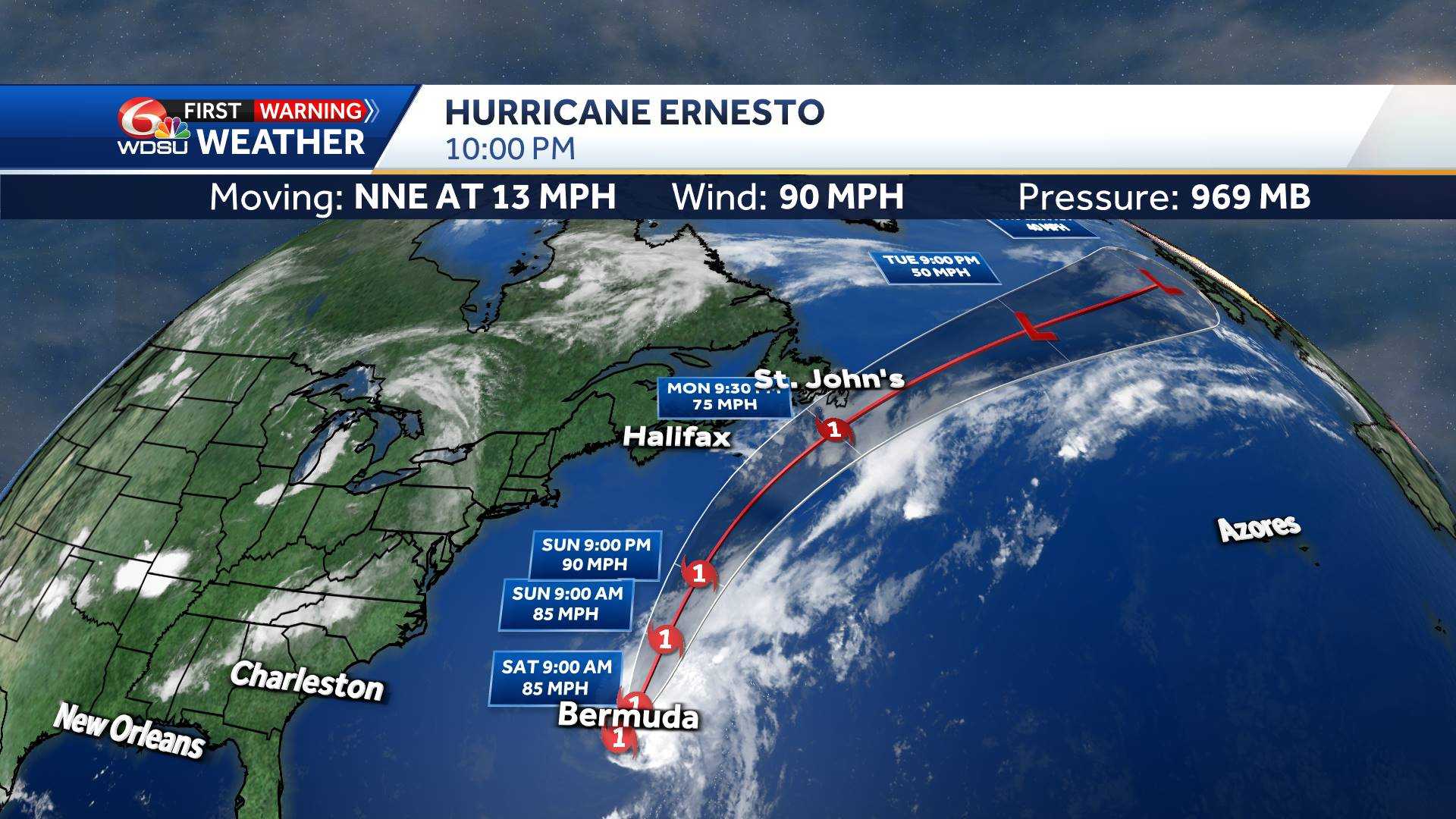
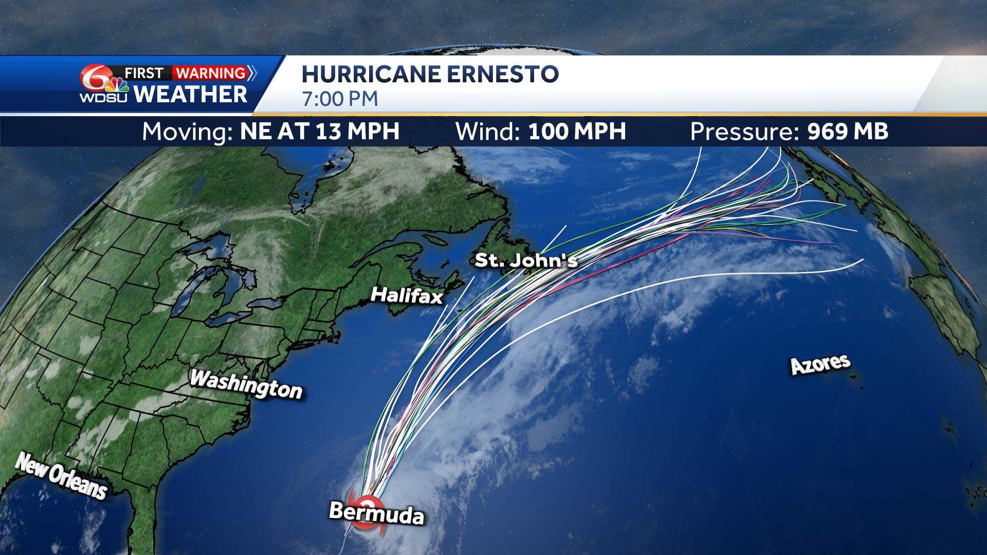
Hurricane forecast tracks are in excellent agreement in taking the storm just east Puerto Rico and right throug the U.S. Virgin Islands tonight as a tropical storm, then heading north towards Bermuda.
The storm is then forecast to strengthen to a category 3 hurricane and could possibly impact Bermuda by Saturday.
Again, this storm will not affect the Continental U.S. or Louisiana at all.
However, there is some good news! Besides Ernesto, there isn't anything forecast to develop in the Atlantic or Caribbean over the next 7 days.
The Gulf of Mexico also looks to be free of any development over the next 7 days as well!
And updated just today, the long rang forecasts for the next 2 to 3 weeks show the potential of the Main Development Region (MDR) becoming very active by the end of August. BUT... the outlined area suggests that storms might be caught in the Bermuda high, and just like Ernesto, move north just off the east coast of the U.S.
This forecast can contain much more uncertainty, but we'll be sure to keep you informed on any changes.
Be sure to stay up with all the latest tropical forecast information with the entire WDSU First Warning Weather Team as well. Take care.


